We finally crossed into Georgia! We were a bit uncertain of the exact spot but somewhere around the Savannah River. We have been fortunate up until this point because we have had the tides working to our advantage. We have been able to leave on a low to rising tide and ride south on a good current. This made some of the areas that are known shoaling problems less of an issue because we went through them at close to high tide. It may not sound important but when the tides average 5-6' it make all the difference. Our luck held out until the very end....but more on this later.

Bridges, bridges, bridges our bane. I am sure that the cars that need to wait feel frustrated too, but I would bet not as much as we are. Our height is a bit under 29' with our antennas down and about 42' with them up. Most bridges will not open if you can clear with your antennas down so you will need to put them down as you wait and spin around in the current near other boaters. There are three types of clearances we encounter, first are those who have a very high clearance, big highways and the like have clearances of 65' or greater. We like these. Then there are those that have very low clearances of a few feet up to the low 20's, these are not our favorite but usually there is no question of whether you need an opening. Then there are those who height is a definite "maybe". At high tide we cannot get through and at low tide we can and need to drop our antennas.
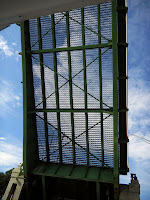
This is the Wilmington River Bridge (Causton Bluff bascule bridge), the bridge tender challenged us about our height and then reluctantly opened it. We were on the edge of maybe getting under it or then again maybe not. If the tide had been really high or really low the decision would have been obvious, but this was a mid tide so it was less clear. Our position has been to be conservative and, when in doubt, don't take chances. We felt a bit guilty though because of the tone from the bridge tender.
We passed Thunderbolt Ga on our way to Isle of Hope which is outside of Savannah Ga. Here is a really big yard that caters to the large mega yacht crowd. This bad boy was departing as we went by. They run to the ocean, which is about 5 miles away and was most likely headed to warmer waters down south. Who can blame them?
This brings us back to the tide issue. We have been fortunate to have favorable tides until we arrived in Isle of Hope. Our next day trip would take us through the notorious shallow Mud River which must be traveled on a high tide. No matter how we looked at it the tide did not work in our favor. We would need to be there at 4pm and it would leave us short of our destination for the day. So it was awkward to find a good solution. We decided to run outside from Ossabaw Sound to St. Simon s Inlet. A trip of 80 nautical miles (1 nm = 1.15 statue miles).
The weather the day before called for 2-3', seas building to 3-4 in the afternoon.with an approaching cold front. This meant we needed to leave in the dark and travel to a bridge for a 7am opening. This particular bridge had a rush hour restriction and would only open on the hour 6:30-9am. We do not like traveling the ICW in the dark in general, but it would be the only way to make it work. In the morning the weather forecast seemed worse, with seas of 3-4 building to 4-6 and wind in the 20kts range form the N/NW.
We traveled to the Skidaway Narrows Bridge departing 6:20 am (sunrise 7:10am) and used our spot light and charts to follow the twisting and winding ICW. We arrived at the bridge 20 min before opening and having concluding our negotiations about our height, (we were in the gray zone because of the tide) we waited for the opening. This is the early morning sunrise off our port side as we waited.
We traveled on through the bridge at 7am and next passed through Hells Gate another notorious problem area that was recently dredged. This is the point where the ICW turns to the west and the ocean is to the east. We were still up in the air about which course to take due to the worsening weather forecast. It was very calm this time of day; the water was flat so we decided to go for it and travel outside. We had prepared for this so the things that might not be stable with a rolling sea were secured.

One of the reasons we opted to go outside was the wind direction which would be on our stern and we would get a push. We really enjoy the ICW. It is interesting, entertaining and always a surprise. Running outside is ...well kinda boring. You are on autopilot and traveling from way point to way point. The view is pretty much the same. We were buttoned up inside the pilot house warm and cozy. The seas where 3-4' with an occasional 5', all on our stern. We made great time with an average speed of 9.5 kts. This route was not shorter, rather it might have been a wee bit longer. However, we went faster not worrying about shoaling, no wake zones or bridges. So, while traveling outside, we did boat chores some cleaning and laundry. We saw only one other boat the entire day trip, otherwise it was just us. We average traveling 6-10 miles offshore. Our last time in this area was an overnight trip from Fernandina Beach Fla to Georgetown SC last summer ( 226nm) coming north, so this was an easy day trip.
We arrived at Brunswick Landing Marina in Brunswick Ga at 3:30pm. The only really snotty seas were when we turned west to enter the shipping channel in to St. Simons Inlet; we were taking 4-5 footers on our stbd beam and had to work a bit to stay in the channel as the waves wanted to push us out. Once past the last sea channel markers at 2:20pm the seas calmed down to a flat surface and we went up the channel passing two larger commercial cargo ships and into the marina.
We are now as far south as we can get before entering Fla waters. Here we will wait until after the Christmas and New Years holidays. We cannot reenter Fla for 180 days since we left or we would have to pay Fla sales tax (yikes), so in southern Ga we wait.
You can check out our route for the next few days on the SPOT link at the side or by clicking here
http://share.findmespot.com/shared/faces/viewspots.jsp?glId=0YbgAe68AMPZoLxpBHQYaVI86IlerZvb3
So far we have travels on our trip south 662 nautical miles or 761.3 statue miles of which 680 sm are the twisting and turning ICW. Since June we have logged almost 3000 miles. Including our north trip from Ft Lauderdale to Block Island & Kuttyhunk Ma., and back to the Chesapeake Bay before beginning this southern leg in November 2009.


No comments:
Post a Comment
Note: Only a member of this blog may post a comment.